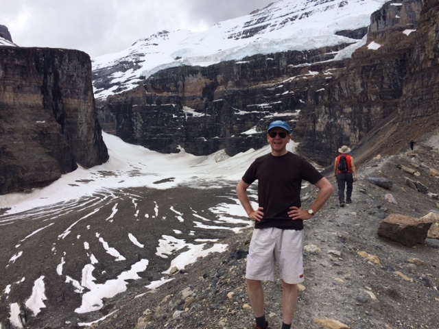
Thank you to everyone who followed along and encouraged Ted Bosley and Scott Sinclair as they tackled hiking the historic John Muir Trail to raise funds for the Gamble House Junior Docent Program!

AUGUST 22ND:
BRAVO! THEY’VE DONE IT!! Ted and Scott have reached Mount Whitney. CONGRATULATIONS!! We can’t wait to see the pictures and hear all about this wonderful adventure.

AUGUST 21TH:
Lots of movement from our dynamic duo today. They have passed Guitar Lake (which looks very cool) and quickly ascending the remainder of the trail.

AUGUST 20TH:
Today we’ll let the map do the talking for us…GO TED, GO, GO, GO!! They are at Crabtree Meadow hiking along the Whitney Creek.
Latitude: 36.56429 | Longitude: -118.34891


AUGUST 18TH:
Today’s update is to let you (and reassure ourselves) that Ted is “ok” on this hike with all the fires in the Kings Canyon and Sequoia National Park areas. We are tracking his every move and they are progressing. We’re not sure what the air quality is like where he’s at but we do know he’s physically in no danger at this time. Below is a map of active fire locations that we are checking daily, so we’ll try to keep you all up-to-date on things.
Ted and Scott are on the final portion of the trail, descending along Bubbs Creek, passing through Vidette Meadow (lots of bear boxes in this stretch – yikes!), on past a pyramid shaped mountain called Junction Peak (13,888 feet), then at the far end of Bubbs Creek Canyon are the Kearsarge Pinnacles. They are heading to Junction Peak and Forester Pass which lies at 12,250 feet (higher than Pinchot Pass). Not only is this the highest pass on the John Muir Trail, but also it is the highest pass on the entire Pacific Crest Trail (which goes more than 2,100 miles from the Mexican border to the Canadian border). Forester Pass also marks the boundary between Kings Canyon and Sequoia National Parks.
Latitude: 36.73067 | Longitude: -118.37309

Pinnacles Peak

Vidette Meadow

Bubbs Creek
AUGUST 17TH (part 2):
Ted and Scott made such great progress today that we wanted to give you a part 2 update on their location. They crossed the Woods Creek Suspension Bridge (see the video we found on YouTube to give you virtual experience of crossing the bridge), which is only wide enough for one person. At this point they are at about 8500 ft (elevation) in contrast to their recent elevation of around 12,000ft. They are now in the Rae Lakes area which boasts some gorgeous scenery and is packed with a number of picturesque mountain peaks (Fin Dome, Black Mountain, Dragon Peak and Painted Lady).


AUGUST 17TH:
Today’s checkin is very exciting because it’s the first time we can see Mt. Whitney on the live map overview! They still have a nice chunk of the trail to go though.
The trail comes somewhat close to the two Twin Lakes, just below Mt. Cedric Wright. Here they have a view of Mt. Clarence King – another iconic mountain in the Sierra Nevada.
From here they’ll head on to the South Fork and into a very popular portion of the trail.

AUGUST 16TH & 15TH:
Here is a description of what this portion of the trail it like for hikers. One of the most under appreciated parks in the National Park System is Kings Canyon National Park. Most visitors only travel to the western side of the park, where the “main” and only road enters the heart of the canyon portion of the park. This portion of the park does not have the classic domes or sheer walls of Yosemite Valley or the giant sequoia trees like Sequoia National Park which is why it may take a backseat to its neighbors. However, the back country of Kings Canyon National Park is unrivaled — the is where the park truly shines
The John Muir Trail travels about 75 miles in Kings Canyon National Park. The entire length of the trail in Kings Canyon National Park is only accessible by foot or stock. It is one of most remote trails anywhere in the United States. This is unfortunate as a vast majority of visitors to Kings Canyon National Park only experience a small fraction of the wonders of this part. For Kings Canyon National Park is one of the most beautiful parks in the world. As you hike, you be the judge, but finding places more beautiful than such places as the Rae Lakes area, Marie Lake, Upper Basin, Le Conte Canyon, Evolution Valley and McClure Meadow is nearly impossible.
This section of the trail is also one of the most challenging. Traveling along the trail in this section one will cross five passes, numerous valleys and major watersheds such as the South Fork Kings River. Although further south Mt. Whitney receives a majority of the attention, this section of the trail skirts near other 14,000 foot mountains such as: Thunderbolt Peak, Polemonium Peak, Mount Sill, Split Mountain, Mount Tyndall, Mount Williamson, and the Palisades. In fact, the Trail leaves this national park at Forester Pass (13,180) – The highest pass on not only this trail, but the Pacific Crest Trail as well.
(This description comes from the main Muir Trail website)

AUGUST 14TH:
Ted and Scott are heading into a pretty steep portion of the trail with upper elevations ranging between 10,000 and about 14,000 feet. Whew! They are around Pinchot Pass is at 12,130 feet — yet another new high point. Pinchot is the 2nd highest pass on the John Muir Trail. There are several lakes in this area (most unnamed) and a number of switchbacks to tackle.

AUGUST 13TH:
Ted and Scott are tackling the Muir Pass at Le Conte Canyon. This is another beautiful spot where a nice often gentle creek turns into a river. This long canyon has beautify meadows and classic mountain peaks. It has been shaped by the Middle Fork of the Kings River. As the John Muir Trail transitions from an East direction to a South direction, views of Big Pete Meadows and distant peaks come into view.
Latitude: 37.08907 | Longitude: -118.59558
AUGUST 12TH:
Ted and Scott are approaching Evolution Lake. Many describe Evolution Valley and Lake area as the most beautiful place in the Sierra. It’s tranquil with grassy meadows and a lovely stream and plenty of fabulous spots to setup camp.
Latitude: 37.17255 | Longitude : -118.69995


AUGUST 10TH & 11TH:
Ted and Scott have made it to the Muir Trail Ranch – IT’S THE HALFWAY POINT for the hike!! This allowed them time to restock their supplies from a cache that they stored on an earlier conditioning hike prior to starting the “real thing” on August 4th.
Latitude: 37.23479 | Longitude : -118.87999

A little about the Muir Trail Ranch (from their site):
The ranch was first opened for use by the vacationing public in 1940. At that time, it was called the Diamond D Guest Ranch. Prior to that it was used every summer by cattlemen and shepherds who drove their herds into the high-country meadows clear into what is now Sequoia-Kings Canyon National Park. Even earlier, American Indians from the east side of the Sierra came over Paiute Pass on their way to trade with the tribes in the foothills near Auberry. One of their major summer-use campsites was in what is now called Blayney Meadow on the western-most part of the ranch.
Later still, the area became a mecca for people traveling on foot or horseback. In 1947 the Muir Trail was completed and became one of the most popular trails in the United States, attracting thousands of users every summer. After peaking in popularity in the mid-1970s, traffic has slowed to such an extent that some hikers report going for a week without seeing another soul along the trail, a special treat for European hikers weary of the crowds in the Alps.
The oldest building on the ranch is what we call the “Shipp Shake” cabin. It was built of hand-hewn logs and hand-split pine shakes by one of the ranch’s original owners, the Shipp family, around 1895. Sallie Keyes Lakes are named for Sallie Keyes Shipp, their daughter.
AUGUST 8TH & 9TH:
Ted and Scott continue to make their way along beautiful Bear Creek. We hope it’s cooler there than it has been in LA!
Latitude: 37.35324 | Longitude : -118.87772

AUGUST 7TH:
Ted and Scott are moving along and are climbing Bear Ridge – it’s very challenging with more or less 60 steep switchbacks! The views are a lovely mix of Aspen groves and the changeable beauty (mix of small rapid cascades and calm water) of Bear Creek. Not a bad place to spend a Friday!
Latitude: 37.36177 | Longitude: -118.95419

AUGUST 6TH: SILVER PASS
Ted and Scott tackled the Silver Pass today. They are now at the southern edge of Silver Pass Lake.
Latitude: 37.45445 | Longitude: -118.92242
Silver Pass is located on the Silver Divide — an east to west ridge of the Sierra Nevada. Not more than a little over a mile west of Silver Pass is Goodale Pass (at a slightly higher elevation).
Silver Pass rises to 10,900 feet and is the 7th highest pass, of the eight “true” passes on the John Muir Trail.

AUGUST 5TH: LAKE VIRGINIA
Ted Bosley and his hiking partner Scott Sinclair reached a pass with a beautiful meadow on the edge of Lake Virginia! What a picturesque campsite!
Latitude: 37.51323 | Longitude: -118.93707

August 17, 2015 - 10:00 pm
Hey, Ted…
Just found our that i can follow you via vicarious updates. Hope the smoke has;’t been too bad.
Go, Ted, Go!!!
August 30, 2015 - 12:39 am
Congrats Ted! Look forward to seeing the pictures and hearing the tales of your journey.